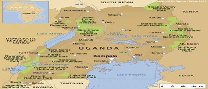
Uganda National Parks Map: Ten Parks, One Compact Country
Uganda national parks map reveals ten protected areas concentrated into a country roughly the size of the UK — making multi-park safaris more logistically manageable than in larger East African destinations. Uganda Wildlife Authority manages all ten parks. Each offers a distinct ecosystem and species profile. Understanding the geographic distribution of these parks helps you build efficient circuits without excessive backtracking across the country’s varied terrain.
Uganda National Parks Map: The Western Circuit
Four of Uganda’s most visited parks cluster in the western region accessible from Fort Portal and Kabale. Kibale Forest National Park sits southeast of Fort Portal and holds Uganda’s finest chimpanzee trekking. Queen Elizabeth National Park lies south of Kibale and delivers classic savannah game drives alongside Kazinga Channel boat safaris. Bwindi Impenetrable Forest sits in the southwestern corner bordering DRC and Rwanda — the home of mountain gorilla trekking. Mgahinga Gorilla National Park sits immediately east of Bwindi at the base of the Virunga volcanoes. Combining all four western parks in a single eight to ten-day circuit covers Uganda’s headline wildlife experiences.
Uganda National Parks Map: Semuliki and Lake Mburo
Semuliki National Park sits north of Kibale near the DRC border and offers hot springs, bat cave walks and Albertine Rift endemic birding. Lake Mburo National Park lies east of Mbarara on the road between Kampala and western parks — flat, zebra-rich terrain ideal for afternoon game drives and horse safaris. Both parks work well as add-ons to the western circuit for travelers with time to spare.
Uganda National Parks Map: Northern Parks
Murchison Falls National Park dominates the north, bisected by the Victoria Nile and famous for its dramatic falls and excellent elephant and lion populations. The park sits four to five hours from Kampala by road. Budongo Forest on Murchison’s southern boundary offers chimpanzee trekking as an alternative to Kibale. Kidepo Valley National Park occupies the far northeast corner near South Sudan and requires a domestic charter flight or nine-hour road journey. These northern parks suit itineraries that combine western circuit primates with northern savannah game viewing.
Uganda National Parks Map: Eastern Parks and Entebbe
Uganda national parks map shows Mount Elgon National Park in the far east near the Kenya border — Uganda’s largest volcanic caldera, suited to multi-day hiking expeditions. Rwenzori Mountains National Park sits on the DRC border west of Fort Portal, offering technical glacier trekking and Albertine Rift endemic bird surveys at altitude. Neither Elgon nor Rwenzori suits the standard safari circuit. Both appeal to specialist hikers and birders who add them to extended itineraries.
Uganda National Parks Map: Which Parks to Prioritise
First-time visitors to Uganda should prioritise Bwindi, Kibale and Queen Elizabeth as the three parks that define the Uganda safari experience. Bwindi delivers the gorilla encounter. Kibale delivers chimpanzee trekking at Africa’s highest chimp density. Queen Elizabeth delivers savannah game drives and the Kazinga Channel boat safari. Adding Murchison Falls for a four-park circuit creates a ten to twelve-day itinerary covering Uganda’s complete wildlife portfolio.
Uganda National Parks Map: Distance and Drive Times
| Route | Distance | Drive Time |
|---|---|---|
| Entebbe to Kibale | 320 km | 4-5 hours |
| Kibale to Queen Elizabeth | 100 km | 2-3 hours |
| Queen Elizabeth to Bwindi | 150 km | 3-4 hours |
| Entebbe to Murchison Falls | 305 km | 4-5 hours |
| Entebbe to Kidepo (fly) | — | 90 minutes |
Uganda National Parks Map: Building Your Circuit
Uganda national parks map planning works best when you start your circuit from Entebbe and loop west and south before returning northeast to Kampala or Entebbe for departure. The classic western circuit departs Entebbe, drives to Kibale (day 1), treks chimps at Kibale (day 2), continues to Queen Elizabeth (day 3) for game drives and the boat safari (day 4), then drives south to Bwindi (day 5) for the gorilla trek (day 6). Return via Kabale and Masaka to Entebbe or Kampala on day 7. This seven-day circuit is the most popular Uganda safari format for first-time visitors.
Uganda National Parks Map: Adding Murchison Falls
Adding Murchison Falls National Park requires returning north from Entebbe before or after the western circuit. Most operators structure the Murchison leg before the western circuit — drive north from Entebbe on day 1, game drive Murchison on days 2 and 3, then fly or drive south to Kibale to begin the western circuit on day 4. A domestic charter flight from Pakuba Airstrip inside Murchison to Kasese (for Queen Elizabeth) or Kisoro (for Bwindi) saves significant road time on this expanded circuit.
Plan Your Tour
Build Your Uganda National Park Circuit
Custom Multi-Park Itinerary Planning
African Wild Trekkers builds Uganda circuits across any combination of parks matched to your time, budget and wildlife priorities. We handle all park permits, lodge bookings and road or flight logistics. Contact us at africanwildtrekkers.com/contact with your travel dates and preferred parks.
All Logistics Included
Private vehicle with driver-guide, all permits, full-board lodge accommodation, park entry fees and airport transfers are confirmed in your itinerary before departure. No logistics decisions fall to you during the trip.
Why Book With African Wild Trekkers
Uganda Circuit Specialists
Our team has driven and trekked every Uganda national park personally. We design efficient circuits that maximise wildlife time and minimise road transfer fatigue across your available days.
Get Your Free Circuit Quote
Visit africanwildtrekkers.com/contact. We respond within 24 hours and send your Uganda multi-park itinerary within three working days.