Wildlife Census Count Africa: How East Africa’s Wildlife Populations Are Monitored
Conservation management without accurate population data is guesswork. Knowing how many elephants inhabit a given ecosystem, which direction the wildebeest migration currently moves, or whether the black rhino population in a specific conservancy is growing or shrinking determines every management decision — anti-poaching resource allocation, habitat restoration priorities, human-wildlife conflict mitigation budgets, and the sustainable hunting or tourism quotas that generate revenue for wildlife protection. East Africa’s wildlife census operations — aerial, ground-based, and increasingly satellite-assisted — represent some of the most technically sophisticated wildlife monitoring in the world. They also represent one of the most directly accessible ways for safari visitors to contribute to conservation through citizen science participation.
Aerial Census Methods
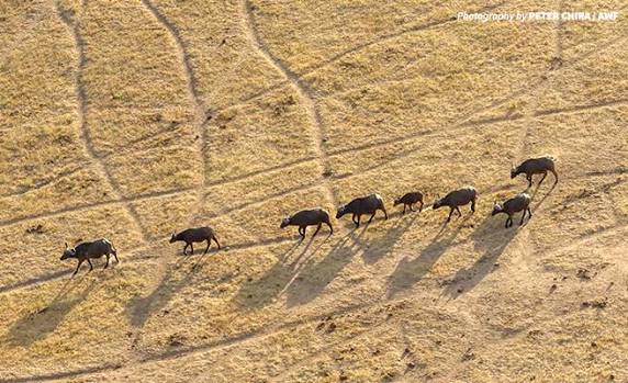
The aerial census remains the primary method for counting large mammal populations across East Africa’s vast protected areas. A fixed-wing aircraft flies parallel transect lines at a fixed altitude — typically 90 to 120 metres above ground — at a defined airspeed. Trained observers seated at each window count every animal of each species seen within a defined strip width on either side of the aircraft. Total counts are then statistically extrapolated from the sampled transect lines to produce a population estimate for the full survey area. Kenya’s national aerial survey, managed by the Kenya Wildlife Service, covers the country’s key wildlife areas every two to three years. Tanzania’s aerial survey programme covers the Serengeti ecosystem, Selous-Nyerere, and Ruaha annually. Furthermore, the results of these surveys provide the most robust population estimates available for East Africa’s major wildlife species.
Ground-Based Monitoring
Aerial censuses provide ecosystem-scale estimates but miss the behavioural and demographic data that ground-based monitoring delivers. Camera trap networks provide occupancy and density estimates for cryptic species that aerial surveys undercount. Direct observation studies — ranger teams recording every individual animal seen during patrol routes — provide continuous, year-round data on species composition, group sizes, and movement patterns. Mark-recapture methods, using individual identification from unique markings — ear notch patterns in rhinos, stripe patterns in zebras, tail fluke patterns in dolphins — provide population estimates with much lower statistical uncertainty than transect counting. Additionally, GPS collar data from selected individuals tracks movement, ranging behaviour, and corridor use for species from elephants to wild dogs.
Citizen Science Participation
Several East Africa conservation programmes actively recruit safari visitors as citizen science data collectors. Snapshot Masai Mara and Snapshot Serengeti use camera trap images classified by citizen scientists on the Zooniverse platform — over 1 million images from East Africa’s camera trap networks require classification every year, and trained citizen scientists working online contribute classification decisions that professional researchers could not process at this scale. Additionally, the iNaturalist platform accepts wildlife observation records from safari visitors — photographs with GPS coordinates and species identification contribute directly to the biodiversity observation database used by conservation organisations and government wildlife agencies across East Africa. The Wildebeest Migration monitoring programme accepts visitor sightings data through camp-operated reporting systems during the migration season.
Plan Your Safari
Visitor participation in census activities is most accessible through conservancy-based research programmes in Kenya’s Laikipia Plateau, the Maasai Mara ecosystem, and Tanzania’s northern circuit. Camps associated with research organisations — the Mara Predator Conservation Programme, Ol Pejeta Conservancy’s research team, and the Lewa Wildlife Conservancy’s monitoring programme — offer the most direct participation opportunities. Submitting iNaturalist records from any East Africa safari contributes to the citizen science database regardless of destination. A guide who understands the value of citizen science data collection can assist in recording observations accurately throughout any itinerary.
African Wild Trekkers connects guests with research-active camps and citizen science programmes across East Africa. Contact us to plan a safari that contributes meaningfully to the wildlife monitoring that underpins East Africa’s conservation success.